Translate

Showing posts with label air. Show all posts

Sunday, June 18, 2023

I Scream, You Scream, We All Scream for Isoprene

Plants are well known for absorbing carbon dioxide from the atmosphere and replacing it with oxygen as part of the photosynthesis process. But that’s not the only thing they put into the air. Trees emit tons of a chemical known as isoprene every year, mostly during summer months. It’s surprising to learn that plants contribute to air pollution. 

An abundance of isoprene can lead to formation of greater amounts of ozone by combining with nitrogen in the form of NO and NO2. Ozone in higher levels of the atmosphere is good because it blocks harmful UV rays from the sun, but at our level it’s a major pollutant.  

The current theory is that plants produce isoprene as a method of heat resistance. Like water vapor and oxygen, it is emitted through the pores in a plant’s leaf. Not every plant produces isoprene, but the biggest producers in the US are oaks and poplars.  

Shenandoah National Park (NPS)

Isoprene is what gives the Blue Ridge Mountains their blue appearance. The chemical haze scatters blue light, which makes the mountains appear blue from a distance. It also gives the Smoky Mountains their smoky appearance. 

Great Smoky Mountains (NPS)

We learn such shocking things about nature. I had no idea before today that plants are polluting the air with volatile organic compounds, which when man-made seem to be about the worst thing under the sun. Yet here they are, also giving some of our national parks their distinguishing features and even namesakes. 

Information comes from National Center for Biotechnology Information and Department of Energy Office of Science.

Friday, May 29, 2020

Energy Alternatives


Energy is important at a biological level to sustain life, and at a societal level to sustain lifestyle. From
the discovery of fire to the Nuclear Age, energy consumption has changed over the years, and has also
changed the planet. Use of fossil fuels is largely to blame for an increase of atmospheric carbon dioxide
and accompanying changes in climate. The search for reliable, alternative energy sources leads down
many paths, each with its own strengths and weaknesses. Over the next few weeks, we will examine
several energy sources in an attempt to determine which the “greenest” is.
Before examining the benefits and drawbacks of alternative energies, a look at what they are an
alternative to, fossil fuels- petroleum, coal, and natural gas- is in order. Fossil fuels are still in use
because they are relatively cheap, easily refined, and provide many jobs.
Oil drilling (Bureau of Land Management)
The drawbacks of fossil fuels, in addition to the carbon dioxide output, is other environmental
degradation associated with extraction and transport. Finally, because it is a finite source, eventually
the supply will run out. As supply drops, more invasive techniques will be used to extract ever scarcer
supplies and price will go up.
Environmental impacts of drilling for oil and gas include habitat loss at the well site and access roads; noise pollution; air pollution from generators, vehicles, gas flaring, and particle matter; soil disturbance; increased erosion from vegetation loss; increased solid and industrial wastes; degraded water quality from runoff of soil and residues; and oil spills. There are also problems from end-use: air pollution, increased carbon emissions, contamination such as may be found at gas stations, and plastic litter (most plastics are petroleum-based).
Mountaintop removal coal mine (Center for Biological Diversity)
After all the environmental and health issues related to fossil fuels, it seems clear that we need an alternative energy source. There are plenty of green alternatives, which we will explore, starting with hydroelectric next week.

Thursday, December 5, 2019

A Breath of Fresh Air

If you like fresh air, you're probably a big fan of the Clean Air Act and its amendments. While the air in many places is far from ideal, prior to federal legislation it was downright deadly in American cities. A clear gray sky on a summer's day in Philadelphia is a little off-putting, but it beats a smothering fog in the valleys outside Pittsburgh. After the deadly Donora smog in 1948 killed 20 and sickened thousands of others. Federal investigators were asked to come in, and determined that air pollution was in fact the killer, among other factors.
Donora smog, 1948 (Smithsonian)
The government prefers to take baby steps when implementing positive change, rather than jumping in feet first, and tackling air pollution is no exception. The first step came in 1955 with the Air Pollution Control Act, which provided funding for research and led to the Clean Air Act of 1963 and Air Quality Act of 1967. These provided the first air quality monitoring.
Pittsburgh in the 1940s (Citylab)
The Clean Air Act of 1970 was a major step forward. It developed limits on pollution and expanded federal enforcement powers. Among the controls included were auto emissions. States were mandated to implement plans to reduce pollution.
The Amendments of 1990 aimed to reduce air pollution linked to acid rain and ozone depletion.
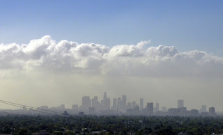
Looking at a picture of the summer sky over Los Angeles, it might be hard to believe the Clean Air Act is working. However, the number of ugly sky days is lower than prior to enactment. Air quality monitors in California frequently show poor quality, and geography is partly to blame. Ocean breezes carry pollution as far as the mountains, where it gets stuck and sometimes builds up for days.
Los Angeles skyline (LAist)
Acid rain has been reduced as a result on the 1990 amendments. pH testing has shown freshwater pH levels in many areas have risen closer to neutral 7. Pure water is neutral, but in nature, water is rarely pure. Pristine rain is slightly acidic because of carbon dioxide in the atmosphere forming carbonic acid. However, the lowered pH in rivers and lakes nationwide was far lower than caused by carbonic acid. Targets of the 1990 amendments were nitrogen oxides (NOx) and sulfur dioxide (SO2). Emissions have been greatly reduced over the last 30 years, and ecosystems are continuing to slowly recover.

Visuals of higher pH meaning less acidic water samples
(National Atmospheric Deposition Program)

Information this week comes the EPA (Clean Air Act overview), Smithsonian Magazine (Donora), and more EPA (acid rain). For a great visual on showing higher pH and lower NOx and SO2, check out the National Atmospheric Deposition Program.

EPA: https://www.epa.gov/clean-air-act-overview/evolution-clean-air-act
Smithsonian: https://www.smithsonianmag.com/history/deadly-donora-smog-1948-spurred-environmental-protection-have-we-forgotten-lesson-180970533/
EPA: https://www.epa.gov/airmarkets/acid-rain-program
nm1 LAist: https://laist.com/2018/10/30/why_las_smog_has_been_extra_smoggy.php
nm2 Citylab: https://www.citylab.com/design/2012/06/what-pittsburgh-looked-when-it-decided-it-had-pollution-problem/2185/
nm3 Smithsonian
nm4 National Atmospheric Deposition Program http://nadp.slh.wisc.edu/data/animaps.aspx

Thursday, October 24, 2019

Changing Leaves

Fall is in full swing. The sun keeps the air warm, but it's chilly in the shade. Honking geese fly overhead and crickets chirp throughout the lengthening nights. Dried leaves swirls about in the breeze, while those still in the trees for a riot of color. What is going on inside the tree that causes the color change?
Trees are getting ready for a long winter's nap. Like animals going into hibernation, everything is slowing down. Trees have been gorging themselves on sunlight all summer, and now their metabolism is slowing down. The chlorophyll is breaking down and water uptake is stopping. Chlorophyll absorbs all wavelengths of light except green, which is reflected back to us. Without chlorophyll, we see other chemicals in the leaf.
A yellow sugar maple catches the late morning sun

The yellow leaf of a sugar maple

Xanthophyll colors the leaves of aspens, birches, and beeches a bright yellow. It's also found in corn.  Red and purple in red maples and scarlet oaks comes from anthocyanin, which is produced when the chlorophyll stops and the leaf metabolizes extra sugars. Carotene, the same as what you find in a carrot, gives trees like sugar maple and sassafras their orange leaves. Orange can also come from a leaf that is showing both xanthophyll and anthocyanin. Brown, such as in oaks, comes from tannins. Carotene and Xanthophyll are present all year in the leaves, but are overshadowed by chlorophyll.
Another sugar maple, this one decked out in red
This red sugar maple leaf fell of a Canadian flag
The brilliance of each color, as well as the amount of colors relative to each other, are dependent on the weather. If fall is sunny and dry, trees will produce more anthocyanin. Trees will be a more brilliant red. Other years, trees won't produce as much or even none at all and nearly all leaves will change to yellow.
But of course, each tree is an individual so it may change well before its neighbor or have different or more vibrant colors, even among the same species. I've seen red maples that look like traffic lights with red, yellow, and green leaves on the same tree. I've even seen multi-colored leaves.
Brown oak leaf, rich in tannin
Yet another sugar maple, this time in orange

Get out there and enjoy some biochemistry in action before it's too late! The leaves have been great this year, peaking in my area this week and next. Up north you may be past peak, and down south it's on its way! This week's information comes from SUNY College of Environmental Science and Forestry and Montana Natural History Center.
Yellow and brown hickories and oaks basking in late
afternoon sunshine

Thursday, June 6, 2019

Hurricane!

With the beginning of June, the northern Atlantic is officially in hurricane season. Tens of millions of people along the East , and in Central America and the Caribbean are at risk from these monster storms annually. Let's have a look at where they come from.
Hurricane! (NOAA)
Hurricanes begin as a low pressure system that gains strength from warm ocean water in or near the tropics. The air moving in to the low pressure area rises, cools, and condenses into clouds. The low pressure continues to draw in more air, and the system begins spinning and forms an eye.
Hurricane formation (NASA)
Wind speeds increase as the storm grows. Despite winds that can exceed 150 miles per hour, most damage is caused by water. As the hurricane approaches land, the wind pushes the water ahead of it. This is called the storm surge. Once the hurricane makes landfall it rapidly loses strength without the warm ocean beneath it. As it moves along, it dumps tremendous amounts of rain, which can cause catastrophic flooding.
Where hurricanes form (NASA)
Thanks to the miracle of satellite radar, we know well in advance of when and where hurricanes will strike. If you are in a hurricane area and are earned to evacuate, please do. Information came from NASA this week.


Thursday, February 28, 2019

Gone With The Wind

It rustles. It rocks us to sleep. It kicks up the surf. It whispers, howls, and screams like the banshees. This week we're talking about the wind. Where does it come from?
On a basic level, the wind is just air moving. But why? Osmosis- air moves from areas of high pressure to areas of low pressure. You can test this yourself by blowing up a balloon, then letting go of the open end. Inside the balloon is more compact. The pressure of the incoming air presses against the balloon, making it expand. Once you let it open the high pressure air rushed out to where there is less pressure.
Low pressure following warm air (NOAA)
So what causes the pressure differences? Temperatures.
Warmer air rises and the molecules spread out. That motion causes an area of low pressure that other air moves in to fill, and we feel that as wind. Storms can cause greater differences in pressure, which leads to higher wind speeds. Hurricanes have extremely low pressure, which explains why they have such strong wind. here.
Wind moving in to fill a void left by warm air rising (NOAA)
Tornados are a whole other ball of wax, which we talked about
Now you know the science behind the wind. Next time it rattles your house or flies your life you'll have a greater understanding of what's going on.
This week's information comes from NOAA.

Thursday, July 12, 2018

Dead Zones

This week we’re taking a look at a problematic summer tradition: hypoxic dead zones. These are marine or aquatic areas that don’t have enough oxygen to support life. The most famous is probably the dead zone in the Gulf of Mexico. Let’s look at dead zones, how they form, and what you can do to help prevent them.
The most common cause of dead zones is excessive nutrient runoff. Nutrients in this case are nitrogen and phosphorus, nutrients from plants. The main source of this nutrient runoff is agriculture, but it can also come from detergents, animal waste, and untreated sewage.
Gulf of Mexico dead zone (Digital Journal)
The nutrient overload leads to a sudden population boom in the local algae community. It seems paradoxical that algae, which produces oxygen, leads to an area without oxygen. First, when a large mat of algae covers the water’s surface it prevents oxygenation at the water/air interface. Then, when the algae dies and decomposes, that is where the oxygen disappears to. Mobile critters like fish can move to more oxygenated areas to survive, but something that can’t move or is very slow like a starfish or sea urchin will suffocate unless the situation clears up.
How a dead zone forms (Gulf Hypoxia)
Sometimes the algae bloom is of a type that produces toxins. Sometimes the toxins cause fish kills. Shellfish can absorb the toxins through filter feeding and pass them on to predators and people. Algae toxins can even threaten public drinking water.
A closer look at an algae bloom (NOAA)

How can you help? Trying to stop non-point pollution seems hopeless, but if everyone ups their game a little bit it adds up and makes a difference. Simple steps you can take at home include limiting the amount of fertilizer you use for your lawn and garden, cleaning up after your pup, and washing your car in the grass rather than the driveway or street. Reducing fertilizer use reduces the amount of excess nitrogen and phosphorus washing into the storm drain and out to sea. If you’re already doing that, buy organic produce which doesn’t use any fertilizer or pesticide. Picking up your dog poop keeps the nitrogen and phosphorus from that source out of the system as well. Washing your car in the yard lets the phosphorus in the detergent soak into the yard rather than washing into the storm drain. Every little bit helps.
This week's information comes from the EPA.

Wednesday, June 27, 2018

Thunderbolts and Lightning, Very Very Frightening Me!


Summer is here, the time of lazy days, high heat, fireflies, and of course, thunderstorms. Thunderstorms can happen anywhere at any time, but are most likely to happen when it gets hot. Here in the east where I live, my thunderstorms are most frequently in the late afternoon. In the Midwest, they usually happen in the evening or overnight. Where do these storms come from?

There are two ways for a thunderstorm to form that I’ve noticed. The first is associated with a cold front. Usually, what I’ve seen is we’ll be in a heat wave (three or more days of temperatures above 90̊) and when a cold front comes in to cool things off a bit, the contrast between very hot and less hot air causes enough atmospheric instability that severe thunderstorms form all along the front.
Afternoon thunderstorm building over Pennsylvania
The other situation, and this is my favorite, is what I call the pop-up storm. These happen later in the day and form when the heat and humidity of the day force hot air to rise. As the air rises it cools and condenses into clouds. If the cloud gets tall enough, the water vapor molecules eventually for ice crystals. If the ice crystals collide with each other, they can create an electrical charge. The electrical charge is lightning. A bolt of lightning is hotter than the surface of the sun and causes the air around it to superheat. The rumble of thunder you hear is the sound of superheated air expanding.
Anvil cloud from a dissipating thunderstorm
Lightning is lazy. When cloud-to-ground lightning strikes, it looks for the shortest and easiest path to the ground. That means the tallest object around. Being in a flat, open area (such as a beach, the rim of the Grand Canyon) or on a prominence such as a hill or mountain makes you a target. Avoid those areas. Also, stay away from tall objects like trees. Get out of the water when you hear thunder. A good rule of thumb is if you can hear thunder, the lightning is close enough to hit you. Pretty much anything indoors is a safe place to hide from lightning, as long as it’s not made completely out of metal.
Lightning strikes near Crater Lake
Another way for thunderstorms to kill you is with a flash flood. Don’t try to drive through water on a roadway. Listen for a rushing sound if you’re hiking in a canyon and move to higher ground. Even if it’s not raining where you are, a flood from rain upstream will find you so be aware of local weather conditions.
A pair of storms approaches in Wyoming
Hail sometimes accompanies a thunderstorm. While it can be cool to see everything covered in ice during the summer, large hailstones can cause property, crop, and people damage. An umbrella won’t protect you from a frozen baseball that’s been falling for thousands of feet so get inside. Also, hail is an indicator of possible tornadoes. Refer back to this post from March.
Odds are pretty good you’ll survive the next thunderstorm. Take the time to relax by listening to the sounds of the rain and thunder. Appreciate all the complexities and nuances that go into making nature’s rumbly light show.
This week's information comes via the National Severe Storms Laboratory All photos are my own.

Thursday, March 29, 2018

Not in Kansas Anymore


Spring is in the air. The return of warmer weather also brings thunderstorms and the start of tornado season, so there's a lot more in the air than just spring. You might associate tornadoes with places like Kansas or Oklahoma, but tornadic activity usually starts in the South in early spring. By May or June, the center of activity moves west to the Lower Midwest, then shifts to the Upper Midwest for June and July. However, tornadoes can strike anywhere at any time. The previously mentioned periods are just the most likely times and locations. Here’s some information about this swirling vortex of death.
Swirling vortex of death (National Weather Service)

The current theory on how a tornado forms is that differing wind speeds during a thunderstorm cause horizontal rotating air columns. If the air column gets caught in an updraft it changes orientation and becomes a vertical column. If the column touches the ground it’s a tornado; otherwise it’s just a funnel cloud.
Tornadoes primarily form in supercell thunderstorms, which are large rotating thunderstorms. Tornadoes will likely drop from a feature of the storm called a wall cloud, which is large low-hanging cloud to the rear of the area of precipitation. It’s far easier for ground spotters to in the Midwest to see wall clouds and storm rotation from a distance than it is for those in other areas.
Wall cloud (National Severe Storms Laboratory)

Having lived in Pennsylvania and Washington all my life, there is no clear horizon in my areas. There are trees, mountains, and buildings in the way. I could tell if a storm was coming based on the clouds in my immediate area. Driving across northern Wyoming, I could see a pair of thunderstorms miles away and the precipitation was visible long before I caught up to it. I didn’t see any rotation or wall clouds, but I was also focused on the road.
Signs to look for during a potentially tornadic thunderstorm are hailstones, green clouds, rotating and/or low hanging clouds, and the loud roar of a freight train. If you observe any or all of these signs, seek shelter immediately.
Another twister (National Severe Storms Laboratory)
Tornado safety
When a tornado watch is issued, it means conditions are favorable for tornado formation. A tornado warning is issued when radar indicates rotation in a storm or a tornado has been seen by a spotter in the field. If a tornado warning is issued, seek immediate shelter. The best place to be is in a basement, but absent that use the downstairs area of a building. A windowless room is best. If there is no windowless room, stay as far from windows as possible. If you can, get under a sturdy table or cover yourself with heavy blankets. If you’re in a high rise, seek shelter in an interior hallway on the lowest floor possible. If outdoors, try to get inside. If you can’t try a vehicle. Buckle up and cover up. Lying in a ditch or depression is also a viable option. If driving, don’t try to outrun a tornado.
This week’s tornado information comes from the National Severe Storms Laboratory and University Corporation for AtmosphericResearch. Safety tips come from Ready.gov.

Thursday, January 11, 2018

Let it Snow

When I was younger, I always wondered why the weatherman could tell us with absolute certainty that it would rain on Thursday, there’d be a thunderstorm at 4:30 on Saturday, and it would be sunny and warm all day Sunday. But when winter sets in there’s snow in the forecast, it was always a lot of “maybe” and “it could”. Now that I’m older and wiser, I can see that a lot of forces are at play when it comes to building a snowflake. What determines whether the weather will be snow, sleet, or just cold rain? Snow requires the right amount of moisture at the right temperature, plus cold enough temperatures from cloud to ground.
Ideally, air temperature should be at least 15̊ F, but not higher than about 40̊ F for it to snow. Warmer air holds more moisture, making it more likely for snow to form, as long as the temperature stays within that narrow threshold.
Part of the uncertainty regarding snow, I think, is my location. All my life I have lived relatively close to the ocean, that great body of temperature-moderating water. The ocean slowly absorbs summer heat, then slowly radiates that stored heat through the winter, keeping the nearby air relatively warm, compared to the middle part of the continent. While it may be cold enough for snow to form in the clouds and stick on the ground, sometimes that warm ocean air forms a layer in between. When that happens, the snow melts and refreezes into sleet pellets or remains liquid rain and freezes on contact with the surface- freezing rain. 


Elevation is one of the factors that matters in predicting precipitation type. Usually, higher elevations are cooler. In my Pennsylvania life that doesn’t matter much, but in Washington it could be the difference between a blizzard and a downpour. There, the snow level (elevation at which snow becomes rain) is a moving target, changing by the day or even hourly. Forecasts from fall through spring frequently mention the snow level, and occasionally it drops to sea level. I once witnessed the spectacle of the snow level moving down the side of a mountain across the road from my cabin. I stood in the rain, waiting for the school bus, as the snow steadily marched downhill. By the time the bus arrived it was snowing where I stood.
Today's snow information comes from the National Snow and Ice Data Center. That nifty chart up above is from Weather Wiz Kids. And don't forget to follow Nature Minute on Facebook if you haven't already.